


Topographical map of the City of Naples and its surroundings
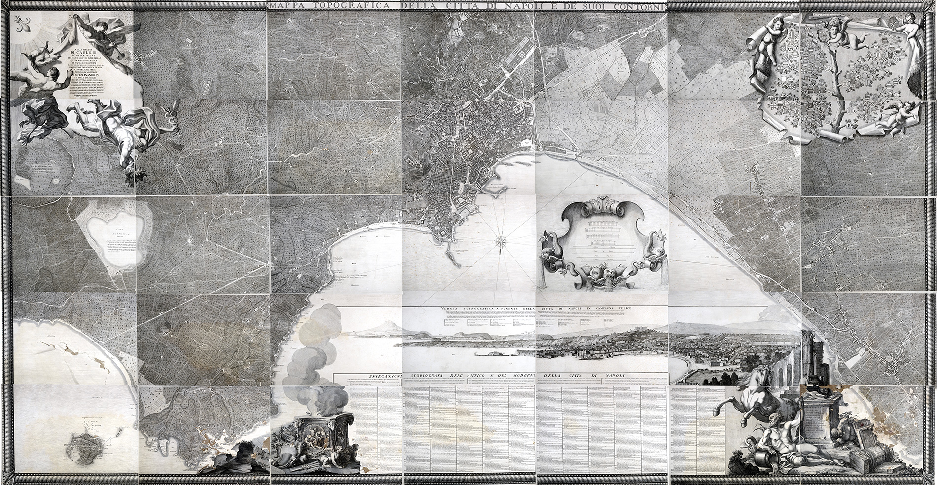
In 1750, the Tribunal of San Lorenzo approved the project to make a topographical map of the city and entrusted the coordination of the work to Giovanni Carafa, Duke of Noja, who availed himself of the collaboration of land surveyor Vanti. It was stipulated that the work was to be completed within two and a half years, but in 1768, when Carafa died, the undertaking was still not finished. Work continued under the direction of Giovanni Pignatelli, Prince of Monteroduni, and the superintendence of the technical part was entrusted to architect Gaetano Bronzuoli.
The work was completed in 1775 after Nicolò Carletti had modified some of the plates by including in them the variants that had occurred up to that time, and accompanied by a toponymic index. The map consists of 35 plates, each measuring 665×480 mm in size, made from copper plates whose engraving was carried out by Giuseppe Aloja, Gaetano Cacace, Pietro Campana and Francesco Lamarra. The bonding framework reaches a total area of approximately 11 square metres.
The map, representing the 18th century Neapolitan territory between Capodimonte, Bagnoli, Nisida and Portici. The first one hundred copies were made by the royal printer Vittorio Barbacci, while the later ones were printed by Antonio Cenci from Rome. The cartography was offered for sale to the public at the price of ten ducats per copy, later reduced to six to facilitate its dissemination, which was, however, severely limited by the high cost of reproduction.
Besides its usefulness as a topographical document, the map was also intended to be an artistic object. It is in fact accompanied in the lower part by a scenographic view of Naples and a legend composed of 580 references with historical and artistic information, and framed by an ornate motif. The upper part of the map bears the dedication to Charles III[1] and Ferdinand IV, on the left side a representation of the coats of arms, subdivided by Seats, of 134 Neapolitan noble families, as well as the royal coat of arms.
The importance of the map is linked to the study of the urban variations that occurred in the city of Naples and its surroundings during the reign of Charles of Bourbon and his son Ferdinand IV. It is also an example of urban planning, in fact some important buildings are depicted there in the form they were intended to take. This is the case of the Real Albergo dei Poveri, a structure begun in 1751 to a design by Ferdinando Fuga which, according to the original idea, was to be 600 metres long and 150 metres wide, but when work stopped in 1819, it had reached a length of 384 metres.
[1]To the Majesty of Charles III, King of Spain, Pious happy august father of the pem,[atria], This topographical map of Naples and its surroundings, begun in his most felicitous government by Giovanni Carafa Duke of Noia, at public expense, and perfected in the present by Ferdinand IV King of the Two Sicilies, Most Excellent Indulgent Prince.
The Order and the People of Naples: Gio. Battista Spinelli Princ. of Cariati for Nilo, F. Giuseppantonio Commen. Francone for Montagna, Gennaro de Maio Duke of S. Pietro for Montagna, Vincenzo Capecelatro Duke of Siano for Capoana, Gio. Battista Albertini Princ. of Cimitile for Portanuova, Andrea di Gennaro March. d’Auletta for Porto, Giuseppe Califano for Lo Popolo